Edmonton’s “Communities on Foot” Maps Were So Cute– Bring Them Back!
- Edmonton

Naomi Brown | Jun 17, 2026
Naomi Brown is a Vancouver-based writer and reporter
City of Edmonton
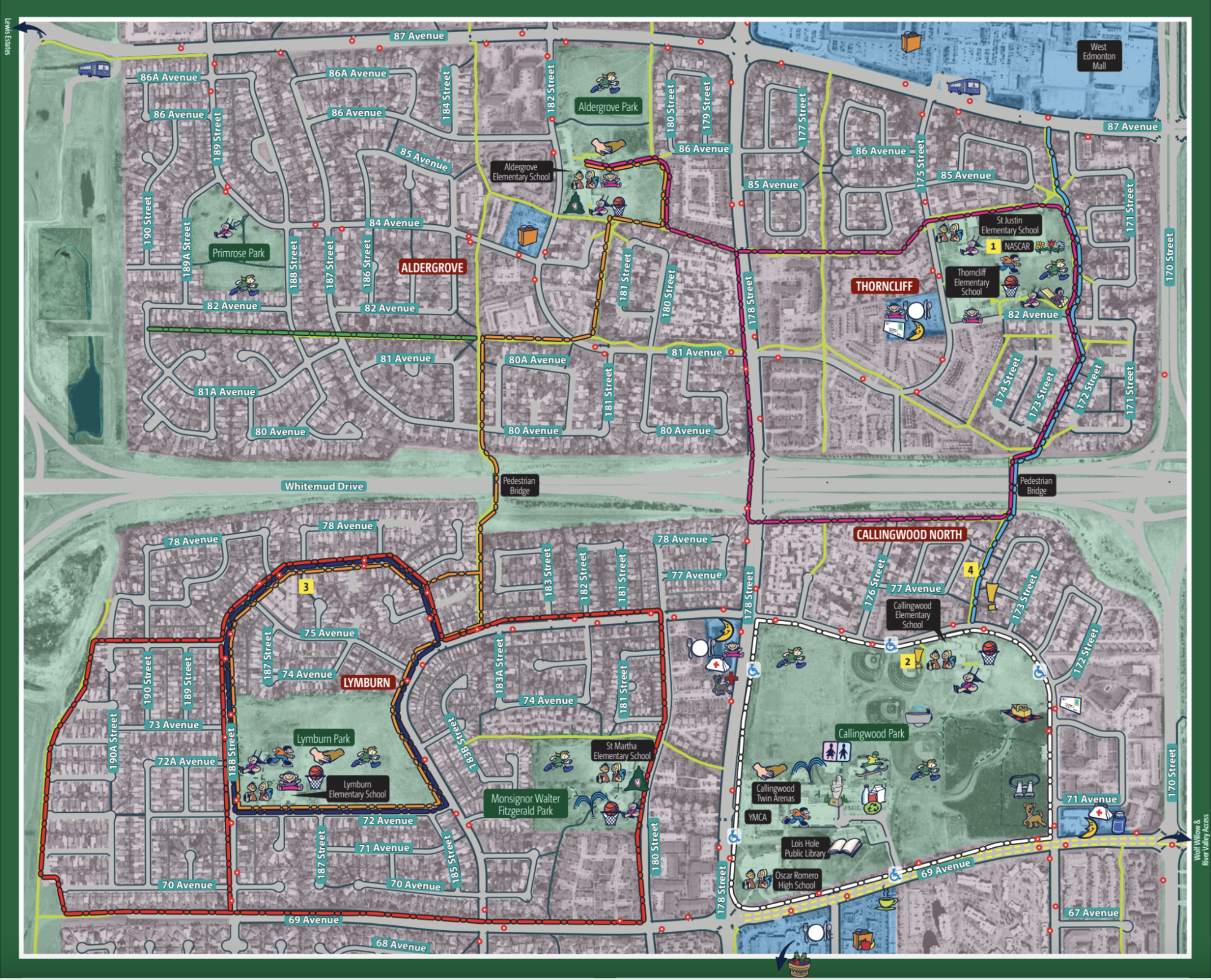
“Community Walking Maps are a series of neighbourhood walking guides, created as joint projects between the City and local community groups to promote walking and walkability in communities across the city”, says The City of Edmonton. Last circulated in the late 2010s, these maps are not only nostalgic but highly practical, and a great way to rediscover your own neighbourhood on foot. Here are four reasons that we propose “Communities on Foot” maps be updated and re-printed:
They provide information and fun facts about your area 📝
This includes historical information about the foundation of neighbourhoods and how they were named. It also extends to events and traditions happening at points of interest throughout the year, and contacts for safety and community resources. There is so much hyper-local information compressed into the first couple of pages. It’s like reading a brochure about a tourist destination, except all of the material is about the place you live and what makes it interesting!
The focus is on walking routes, and free of excess data 🚶
As opposed to tools like Google Maps that are primarily for scoping out and navigating to businesses, these maps are focused on routes you can take by foot. You’ll still pass plenty of destinations such as parks and shops. But, with sample walking routes of various lengths you also get to enjoy the journey and explore.
The maps are zoned by area use, and marked with bus stops 📌
Shaded areas clearly delineate commercial, residential and parkland areas, providing a sense of zones you’ll pass through and what you can do there. Handy red dots represent bus stops, so you can always use transit if you don’t feel like walking back to your starting point. Trails, sidewalks, roadways and alleys are also indicated by different coloured and patterned lines.
The legend marks the location of services, shopping, recreational areas, and special features important to residents of the neighbourhood ☕
It marks essential sites such as schools, post boxes, water fountains and health centres. It also points out the fun stuff like farmer’s markets, cafes, basketball courts and community leagues. The legend uses bright cartoon icons to create a simple visual guide to accessing the goods, services, resources, and experiences you need.
The pictured map is an example of a “Communities on Foot” map that connects four neighbourhoods in North West Edmonton: Aldergrove, Callingwood North, Lymburn, and Thorncliffe. Just look how cute and easy to use!

Access the example map and legend above here
-

Edmonton
Little Wolf Restaurant in Edmonton Welcomes You to Monthly Vegan Dinners for a Cause
- 2 months ago
- Naomi Brown
-

Edmonton
Canada’s Largest Urban Park System is Located in Edmonton
- 2 months ago
- Naomi Brown
-

Edmonton
This Dinner Theatre Experience in Edmonton is the Perfect Date Night
- 2 months ago
- Naomi Brown
Subscribe now for exclusive updates, insightful stories, upcoming events, and the latest happenings across the country.
✅ Thank you! Your email has been submitted.